I am currently working on the edible urban website. Since it’s not complete I can’t share a link to the site, but I can show a screenshot of the work in progress.
The site features an interactive map of potential food growing spaces for selected cities.
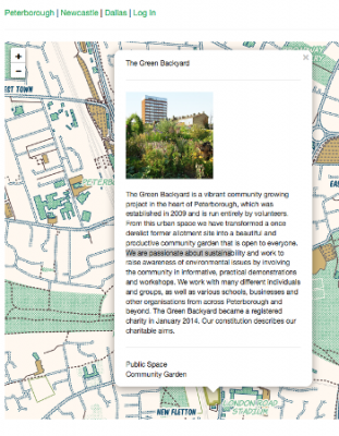
The purpose of the interactive map is to collect data on land availability in cities; rooftops, tarmac, vacant lots, underused grass, land around housing for example. Most people think there isn’t any land available in cities to grow substantial food; this map aims to prove them wrong. In addition to mapping potential spaces, I have also begun to suggest a use for these spaces; for example, aquaponics, community gardens, beekeeping.
You can browse the map by the cities listed below. For these cities I have entered spatial data on land areas (rooftops, vacant land, Tarmac for example), as well as suggested uses for these areas such as community gardens, aquaponics, or commercial gardening. This spatial data on land areas is collected from digital sources (gmaps/ bing for example) and then checked on the ground with extensive walking. This is a long process, which explains the limited cities currently on this page, namely Peterborough and Newcastle in the UK, Hackney and croydon in London, and a selected part of Dallas.
Add your own data!
When browsing the map, you can contribute by adding your of local knowledge of land types, empty buildings, or public grassed spaces. This can be done once you are logged in, by using the polygon tool icon below. This lets you draw a shape on top of the map, around a building, grassed space or car park for example. This can be additional to cities already mapped or a new city. In this way we hope to crowd-source data about potential growing spaces in every city.